questions
- Bergerland is a magical kingdom with a high degree of civilization, a low constant birth rate, a low death rate, and a high degree of female reproductive rights. What stage of the demographic model is Bergerland?
- Syriana is a poor nation with limited access to clean water, and firmly in stage one of the demographic model. What else would we see if we visited there?
- As Syriana increased its access to clean water, what would change and why?
- What is common demographically with Germany, Italy, and Japan, and what will this cause?
Big picture: 15 billion years (BY) ago...
Big bang, then stars which live for about 10 BY, then...
Nova, supernova, neutron stars

4.5 billion years (BY) ago-solar system (including bits from supernovae)
When first stars die as supernovae (about 10 BY into their life), the heat and pressure created all elements beyond Iron on the periodic table
Look up the periodic table and check this out---
so...
Anything on our planet that is lower than Iron on the periodic table, came from the explosion of an older star, including stuff inside YOU.
Earth formed from molten elements as our solar system was formed, (called an accretion disc) including Uranium
(the reason for heat still in the core-see the minister estimate of Sunday afternoon creation date)
Geo time: ("deep time")
 |
| Click for a full-size image |
You can look up the K-T extinction online, it happened 65MY ago. Look up the dude that discovered it...
See videos: How the earth was made...
Layers: (onion boy)
Core-Mantle-Crust-think of an apple


The core is actually two bits: solid inner iron and nickel, liquid outside that bit. It spins, giving us a weak magnetic field
How do we know this? Nuclear bomb testing and our global seismic sensor network
Hint: the inner part spins around in the opposite direction every 60-80 MY, so the earth's magnetic field actually FLIPS (this is important for later-or sooner)
Questions:
- How do we know about the core of the earth?
- Why are our Hawaiian volcanoes different from those in Seattle?
- How do we know about the drift of the continents?
- Near a subduction zone, what type of volcanoes would form, and why?
Plate Tectonics-look up this guy: Wegener. Meteorologist (weather guy), so the geo folks laughed at him...
The players:
Magma-(Dr. Evil voice here: https://www.youtube.com/watch?v=yVo1S52xdpI)
Asthenosphere-"sticky rock" (from Greek ἀσθενής asthenḗs 'weak' + "sphere")
Lithosphere-floating rock (litho = stone) (Ancient Greek: λίθος [lithos] for "rocky", and σφαίρα [sphaira] for "sphere")
Continents-even more floaty, made of lighter rock (granite) that formed from the interaction of magma with oceans
Plates are large, float on the Asthenosphere
Continents are like rafts on the Asthenosphere, more buoyant than the plates
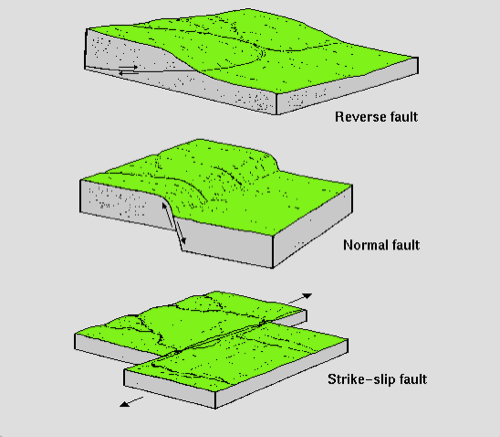
The plates can slide under each other (subduction zones), crash into each other (Himalayas), next to each other (transform faults), and are formed at spreading zones (divergent boundaries)
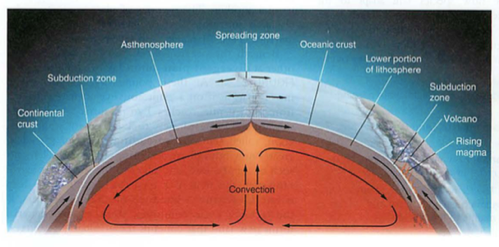 |
| Click for a full-size image |
Check out this diagram: note the red (spreading) and the blue (subducting), esp. look at Chile---->
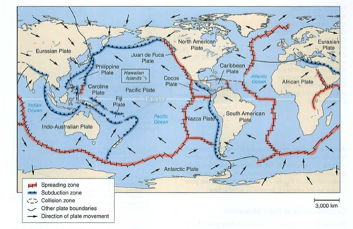 |
| Click for a full-size image |
What mountains are in Chile?
Volcanoes are the key:
Two kinds of volcanoes: Andesitic (pointy), Basaltic (runny, look out your window)
Andesite-from pressure and heat as plates subduct (sticky, high silica content, e.g. Andes mountains)
Basalt-from ocean crust, lots of water, makes for weak, runny magma, formed as magma pushes through watery ocean plates
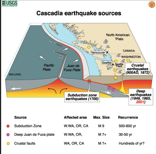
Subduction zones:


Note the sticky stuff boiling up in red-this is why the Andesitic volcanoes are sticky, and always found near subduction zones (Andes, Cascades, Japan, Italy, etc.)
Note also the trench where the subduction zone goes down: this is the origin of the Chilean/Peruvian trench we covered in the El Nino notes, as well as the deepest part of the ocean: the Marianas Trench, which is 7 MILES deep. Whoa!
 |
| Click for a full-size image |
Historic data shows subduction zone quakes that would create a tsunami 1000' high or more on the pacific northwest coast, flooding everything west of I-5.
 |
| Click for a full-size image |
Look at all of the earthquakes (red dots) as the plate subducts
Two things to take-away about subduction zones:
1. subduction zones create ANDESITIC (pointy) volcanoes, which are high in silica, and sticky like thick pancake batter.
2. subduction zones create lots of deep-focus earthquakes.
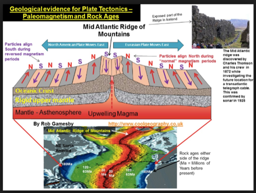
Spreading zones:
--See the submarine notes
What the heck is this?

This might help:
 |
| Click for a full-size image |
Ok, now look at the Oregon coastline:
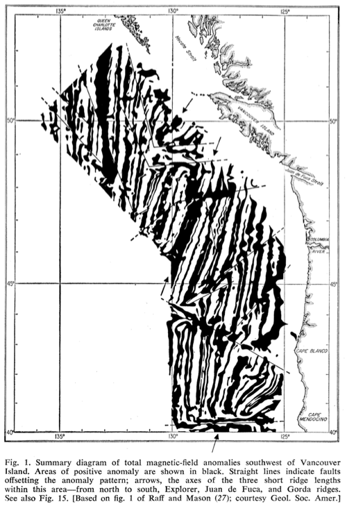 |
| Click for a full-size image |
Note the symmetry along the ridge crest. This was mapped in WWII in an attempt to detect metallic submarines using magnetic sensors on ships. Later on airplanes like this:
 |
| Click for full-size image |

You will see these practicing at the Kona airport, look out for them. They are spying on submarines. Not ours.
 |
| Click for full-size image |
Remember the earth's magnetic field changing?
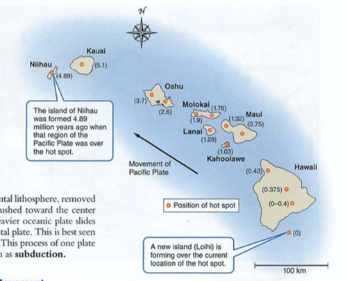
Hot spots:
Usually in the middle of an oceanic plate, but can also be mid-continent (e.g. Yellowstone supervolcano caldera)
Hot spots-basalt-low silica content which melts easier (e.g. look out the window)
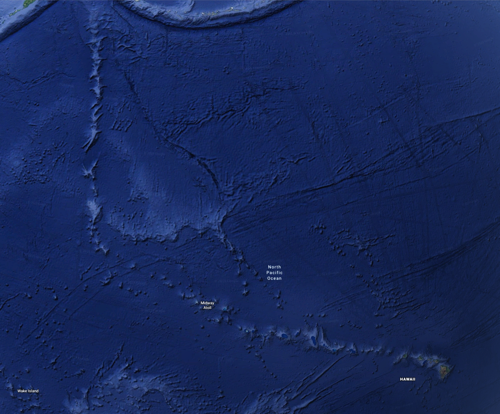
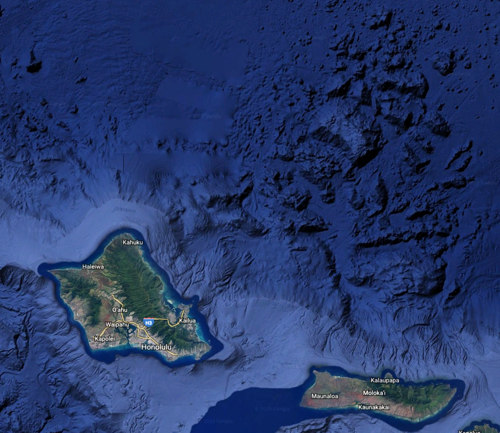
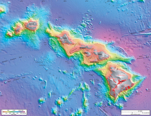
Look at the Hawaii island chain on google earth (underwater version)
While you are at it, look for the Nuuanu landslide that created a 4000' tsunami
You can also look at the Mauna Loa simulated tsunami on youtube...
 |
| Click for a full-size image |
Note the tracking of the pacific plate:
 |
| Click for full-size image |
This is what happens to a shield volcano when it "calves" one side, in this case, the northeast side, in the Nuuanu landslide, one of the largest landslides on earth, causing a tsunami that deposited coral on the top of Mt. Kaala, 4055 ft. high...
 |
| Click for full-size image |
 |
| Click for full-size image |
Earthquakes:
 |
| Click for full-size image |
then there's the famous "not-my" fault...

The epicenter is the place ON THE SURFACE above the hypocenter (true origin) or earthquake FOCUS. Deeper hypocentric quakes often feel "longer", while shallow hypocentric quakes feel "sharp".

How do we find these?
Seismographs:
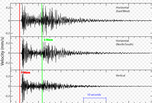
P waves travel by compression (comPression). These are longitudinal waves, like sound. They can travel through liquid or solid.
S waves travel by shear (Shear). These are transverse waves, like a slinky. They can only travel through solids.
This is how we know what the inside of the earth looks like:

This data was found by spying on atomic bomb tests in the 1950s, not because we wanted to know about the guts of our planet...
Ok, back to earthquakes.
Suppose you have a house on posts (called "post and pier" construction). An earthquake happens some distance away. First, your house moves back and forth (P wave, much faster at 8 km/sec). After a time, your house bounces up and down from the S waves (slower at 3 km/second).
If you are far away, these are separated by different arrival times.
If you are near the epicenter, they hit at the same time...up, over, down=your house is demolished
We use this difference to calculate distance from the epicenter (and hypocenter if you are interested) using delay times on the seismograph
 |
| Click for full-size image |
Look at the HPA seismograph here:
and our Hawaii quakes here:
Click on some earthquakes and note the depth and the seismic image.
Next: Rocks Module 25
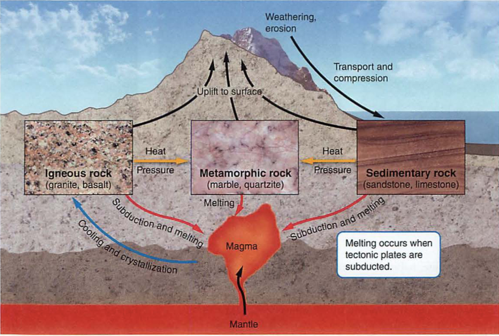
Igneous (fire)
Sedimentary (layers)
Metamorphic (Kafka rocks, just kidding: changed by heat and pressure)
 |
| Click for full-size image |
Igneous= directly from magma, and can be either basalt (low melting point, like our island or oceanic plates) or granite (lighter, what continents are made of)
Granite breaks down into light-colored sand, makes for fertile soil. Basalt (like us) can make sand too, but less fertile (e.g. black sand beach).
Sedimentary= just like it sounds, from mud, sand, or dust, usually in layers.
Metamorphic= changed by heat and/or pressure (slate, marble, or coal)
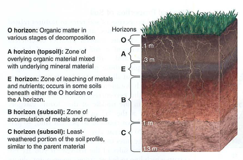
Soil-formed by weathering (chemical or physical) of parent rock
Erosion can be by water or air (wind)
Soil Horizons:
 |
| Click for full-size image |
 |
| Click for full-size image |
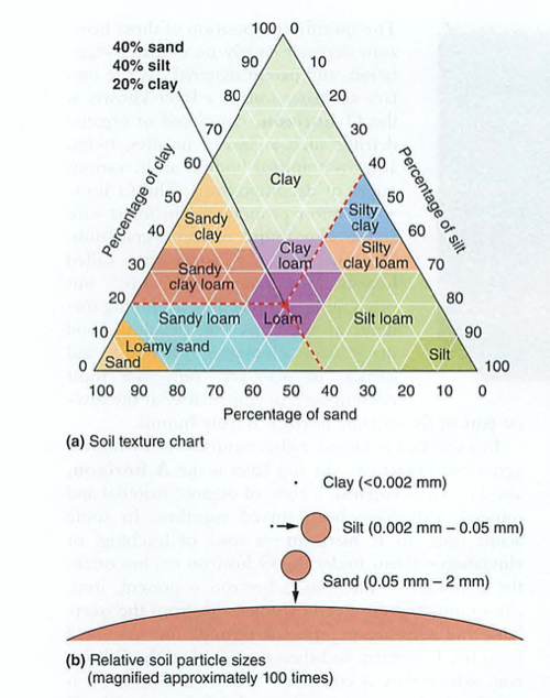
Our Soil Sieve has 4 filters, with 5 layers:
mesh 5 = 4 mm
mesh 10 = 2 mm
mesh 60 = .25 mm
mesh 230 = 0.063 mm
Basically, most of what you find is silt and clay...
/groups/apenvironmentalscience/search/index.rss?tag=hotlist/groups/apenvironmentalscience/search/?tag=hotWhat’s HotHotListHot!?tag=hot6/groups/apenvironmentalscience/sidebar/HotListadminadmin2020-08-19 15:43:59+00:002020-08-19 15:43:59updated30adminadmin2011-09-08 21:36:21+00:002011-09-08 21:36:21updated29adminadmin2011-08-24 23:20:40+00:002011-08-24 23:20:40updated28adminadmin2011-08-24 22:42:36+00:002011-08-24 22:42:36updated27adminadmin2011-08-22 02:41:09+00:002011-08-22 02:41:09updated26adminadmin2011-08-22 02:40:02+00:002011-08-22 02:40:02updated25adminadmin2011-08-21 20:39:11+00:002011-08-21 20:39:11updated24adminadmin2011-08-21 20:30:42+00:002011-08-21 20:30:42updated23adminadmin2011-08-21 20:30:13+00:002011-08-21 20:30:13updated22adminadmin2011-08-21 20:25:48+00:002011-08-21 20:25:48updated21adminadmin2011-08-21 20:25:18+00:002011-08-21 20:25:18updated20adminadmin2011-08-21 00:22:12+00:002011-08-21 00:22:12updated19adminadmin2011-08-21 00:18:56+00:002011-08-21 00:18:56updated18adminadmin2011-08-21 00:15:43+00:002011-08-21 00:15:43updated17adminadmin2011-08-21 00:12:37+00:002011-08-21 00:12:37updated16adminadmin2011-08-21 00:12:02+00:002011-08-21 00:12:02updated15adminadmin2011-08-20 23:59:41+00:002011-08-20 23:59:41updated14Added tag - hotadminadmin2011-08-20 23:59:38+00:002011-08-20 23:59:38addTag13Added tag - conservationadminadmin2011-08-20 23:59:32+00:002011-08-20 23:59:32addTag12Added tag - critical thinkingadminadmin2011-08-20 23:59:19+00:002011-08-20 23:59:19addTag11Added tag - ch1adminadmin2011-08-20 23:59:08+00:002011-08-20 23:59:08addTag10Added tag - sustainabilityadminadmin2011-08-20 23:59:05+00:002011-08-20 23:59:05addTag9adminadmin2011-08-20 20:47:39+00:002011-08-20 20:47:39updated8adminadmin2011-08-20 20:46:15+00:002011-08-20 20:46:15updated7adminadmin2011-08-20 20:43:07+00:002011-08-20 20:43:07updated6adminadmin2011-08-20 19:14:13+00:002011-08-20 19:14:13updated5adminadmin2011-08-20 19:11:26+00:002011-08-20 19:11:26updated4adminadmin2011-08-20 18:59:57+00:002011-08-20 18:59:57updated3adminadmin2011-08-20 18:56:59+00:002011-08-20 18:56:59updated2First createdadminadmin2010-11-07 01:41:28+00:002010-11-07 01:41:28created1wiki2020-08-19T15:43:59+00:00groups/apenvironmentalscience/wiki/welcomeFalseCh01 Overview/groups/apenvironmentalscience/wiki/welcome/Ch01_Overview.htmladmin30 updatesCh01 Overview
Welcome to our APES wiki. You should be able to do the following after logging in with your account:
To create a new page, click the ...Falseadmin2020-08-19T15:43:59+00:00adminadmin2013-02-05 02:24:03+00:002013-02-05 02:24:03updated4Added tag - hotadminadmin2013-02-05 02:24:02+00:002013-02-05 02:24:02addTag3adminadmin2013-02-05 02:05:35+00:002013-02-05 02:05:35updated2First createdadminadmin2013-02-05 02:03:35+00:002013-02-05 02:03:35created1wiki2013-02-05T02:24:03+00:00groups/apenvironmentalscience/wiki/394a8FalseEnergy notes/groups/apenvironmentalscience/wiki/394a8/Energy_notes.htmladmin4 updatesEnergy notes
Week of 2.4.13: energy wrap-up
e2 video: coal vs. nuclear in class
AP exams: FRQ
2002.1
2004.2
2006.1
2007.2
2008.1
...Falseadmin2013-02-05T02:24:03+00:00adminadmin2013-02-05 02:23:20+00:002013-02-05 02:23:20updated6Added tag - hotadminadmin2013-02-05 02:23:18+00:002013-02-05 02:23:18addTag5adminadmin2013-02-05 02:23:12+00:002013-02-05 02:23:12updated4adminadmin2013-02-05 02:21:48+00:002013-02-05 02:21:48updated3adminadmin2013-02-05 02:20:26+00:002013-02-05 02:20:26updated2First createdadminadmin2013-02-05 02:06:00+00:002013-02-05 02:06:00created1wiki2013-02-05T02:23:20+00:00groups/apenvironmentalscience/wiki/c360bFalseFeb-May plan/groups/apenvironmentalscience/wiki/c360b/FebMay_plan.htmladmin6 updatesFeb-May plan
1. conclusion of energy chapters (see previous wiki)
2. GCC AP questions FRQ:
2006.2
2005.3
2005.4
2007.3
...Falseadmin2013-02-05T02:23:20+00:00adminadmin2012-03-07 05:53:55+00:002012-03-07 05:53:55updated14adminadmin2012-03-07 05:43:38+00:002012-03-07 05:43:38updated13adminadmin2012-03-07 05:41:35+00:002012-03-07 05:41:35updated12adminadmin2012-03-07 05:38:57+00:002012-03-07 05:38:57updated11Added tag - hotadminadmin2012-03-07 05:38:55+00:002012-03-07 05:38:55addTag10adminadmin2012-03-07 05:36:47+00:002012-03-07 05:36:47updated9adminadmin2012-03-07 05:22:26+00:002012-03-07 05:22:26updated8adminadmin2012-03-07 05:20:01+00:002012-03-07 05:20:01updated7adminadmin2012-03-07 05:18:58+00:002012-03-07 05:18:58updated6adminadmin2012-03-07 04:58:55+00:002012-03-07 04:58:55updated5adminadmin2012-03-07 04:57:33+00:002012-03-07 04:57:33updated4adminadmin2012-03-07 04:56:53+00:002012-03-07 04:56:53updated3adminadmin2012-03-07 04:54:20+00:002012-03-07 04:54:20updated2First createdadminadmin2012-03-07 04:53:33+00:002012-03-07 04:53:33created1weblog2012-03-07T05:53:55+00:00groups/apenvironmentalscience/weblog/de030FalseGreen Apple/groups/apenvironmentalscience/weblog/de030/Green_Apple.htmladmin14 updatesGreen Apple
Team,
Please watch this video about NYC:
Trailer:
http://www.pbs.org/e2/episodes/101_the_green_apple_trailer.html
On the server:
http://physics.hpa...Falseadmin2012-03-07T05:53:55+00:00adminadmin2011-09-13 19:08:24+00:002011-09-13 19:08:24updated4Added tag - hotadminadmin2011-09-13 19:08:22+00:002011-09-13 19:08:22addTag3adminadmin2011-09-13 19:08:10+00:002011-09-13 19:08:10updated2First createdadminadmin2011-09-13 19:04:30+00:002011-09-13 19:04:30created1weblog2011-09-13T19:08:24+00:00groups/apenvironmentalscience/weblog/4ecddFalseQuestions for Wednesday, wiki adds/groups/apenvironmentalscience/weblog/4ecdd/Questions_for_Wednesday_wiki_adds.htmladmin4 updatesQuestions for Wednesday, wiki adds
Team,
I'd like to try something for class tomorrow: each of you to create a question from chapter 3, and email it to me by this evening (Tuesday). Pl...Falseadmin2011-09-13T19:08:24+00:00hot/groups/apenvironmentalscience/search/index.rss?sort=modifiedDate&kind=all&sortDirection=reverse&excludePages=wiki/welcomelist/groups/apenvironmentalscience/search/?sort=modifiedDate&kind=all&sortDirection=reverse&excludePages=wiki/welcomeRecent ChangesRecentChangesListUpdates?sort=modifiedDate&kind=all&sortDirection=reverse&excludePages=wiki/welcome0/groups/apenvironmentalscience/sidebar/RecentChangesListmodifiedDateallRecent ChangesRecentChangesListUpdateswiki/welcomeNo recent changes.reverse5searchlist/groups/apenvironmentalscience/calendar/Upcoming EventsUpcomingEventsListEvents1Getting events…
Comments