
Points from the e2 video "Portland, sense of place"
- 1973 initiative to create urban growth boundaries (UGB)
- Impact of mass transportation
- Brownfield restoration
- Greenways and greenbelts
- Advent of cars post war and freeways (ca. 1950) enable suburban sprawl
- Sprawl creates food deserts and empty cities with low tax base
Terms:
Urban: in the city
Suburban: outside the city
Exurbs: even farther out
Cities have always developed along rivers, oceans, road routes or rail routes (commerce)
1990-2015: population growth
Denver +70%
Dallas +75%
Atlanta +90%
Phoenix + 104%
Las Vegas +148%
why?
Portland as an example:

n.b. growth during WWII: liberty ships built there
n.b. exodus to suburbs 1950-1973 (freeways)
n.b. city center revitalization post 1973 (as in video)
Suburban flight: Chicago -20%, Philadelphia -25%, Detroit -45%
inner city population drops, suburban population grows
urban->suburban->exurban (way out)
Issue: those with money can move out, taking their tax revenue with them
result: poor funding for core services in the urban area
also: leaves poor folks (no car, lower income) inside the city with poor services (fire, police, libraries, parks)
Sprawl: spread of low density urban suburban or exurban development outwards from a city center
Example: Las Vegas 1986-2013 (look for the city center in each photo)
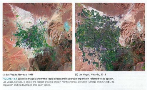
Sprawl is a function of number of people added times amount of land each uses
Detroit 1970-1990:
population -7%
area +28%
Problems:
Transportation: forces folks to buy and maintain a car, longer time in car, more accidents, encourages congestion, requires parking in the cities, increases dependence on oil (how will autonomous cars change this?)
Pollution: cars increase pollution, cities are much more efficient delivery system for energy, water and food, with centralized more efficient transportation options, paved roads increase toxic runoff
Health: folks walk more in cities, driving is less healthy, increasing weight and BP
Land use: suburban and exurban flight consumes valuable farm and forest lands
Economics: flight removes tax base from cities, so critical services suffer
Urban planning: not just roads, also zoning (industrial, commercial, residential)
Think of the growth of Waimea...
1909 Chicago parks around the lakefront (Chicago Fire of 1879 destroyed the city)
1912 Portland plan: waterfront, civic center, boulevards
UGB: Urban Growth Boundaries:
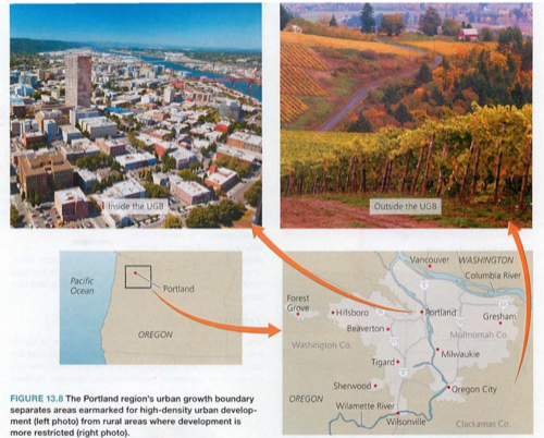
Inside the UGB, urban development is permitted, outside not so
Issues: land owners in outer areas lobby for compensation for their undeveloped land
Gentrification: since there is a limited supply of housing in the nice urban area, only the rich can afford it, forcing poor folks to commute into the city (ironic, but just like Aspen, San Francisco, Santa Barbara or Waikoloa)
(look up the term "Landed Gentry")
An alternative: Smart growth

Recognize these from the e2 video about Portland?
See also transit oriented development: streetcars, buses, light rail, heavy rail, other mass transit
Also: electrified streetcars and trains can use centralized green energy e.g. hydroelectric power (as in Portland)
Urban parks: Central Park NYC, San Francisco Golden Gate park, Boston, Philadelphia
"Biophilic" design concept: "life loving"
opposite of sick building syndrome
Greenways-connected park and trails
Greenbelts-surround urban areas, e.g. Chicago, Toronto, Ottawa, Vancouver
Green Buildings:
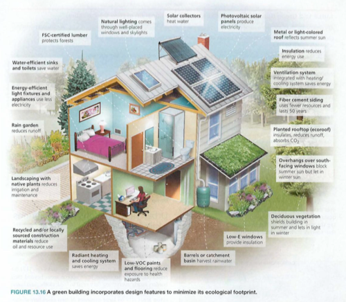
Look for each of these around the elab, the first LEED Platinum school building in Hawaii, second LEED Platinum for Education in the US and First school building ever to win the Living Building Challenge (next).
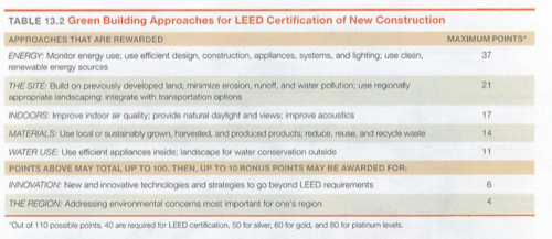
LEED: Leadership in energy and environmental design: silver, gold or platinum (best)
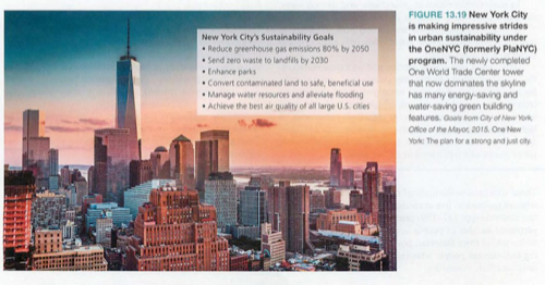
Urban sustainability
NYC is actually the greenest city (see e2 video "NYC-the Green Apple")
Efficient delivery and conservation of energy, water and food
Preserves land
Issue: Urban heat island effect:
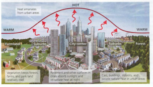
This may not seem to be a problem, but if warmer air is above the city, there is no cooler air aloft to fall (convection) to clean the air, so air pollution increases.
OneNYC plan:
e2 design 1.1 green apple
http://physics.hpa.edu/physics/apenvsci/videos/e2_videos/e2%20design%201/1%20green%20apple.mp4
- Why is it confusing to think of NYC as an ecosystem? Why does it make sense?
- Why is per capita a more accurate measure?
- Why did the guy who moved into the country gain weight?
- A wise person once said that the greatest cities are those built with walking in mind. How is this different in LA?
- Why would a skyscraper be more efficient than a smaller building?
- How did “environmental” become “smarter”?
- How was 4 Times Square a prototype? What other prototype buildings do you know of?
- Last week transparent PV panels were revealed. How would this change the frit concept?
- “blast furnace slag” and fly ash are used for the concrete in the film. Why is fly ash banned in Europe?
- Instead of using drinking water to flush toilets, they use what?
- Why is a 5 year ROI basic business sense?
- How is payback different in Europe and Japan?
- What parts of the Living Building Challenge resonate with this video?
- What would make you want to live in the Solaire, near Battery Park?
- What are the blue things on the side of the building?
- We are 4.6% of the global population, consuming how much of the world’s resources?
Alternate page:
/groups/apenvironmentalscience/search/index.rss?tag=hotlist/groups/apenvironmentalscience/search/?tag=hotWhat’s HotHotListHot!?tag=hot6/groups/apenvironmentalscience/sidebar/HotListadminadmin2020-08-19 15:43:59+00:002020-08-19 15:43:59updated30adminadmin2011-09-08 21:36:21+00:002011-09-08 21:36:21updated29adminadmin2011-08-24 23:20:40+00:002011-08-24 23:20:40updated28adminadmin2011-08-24 22:42:36+00:002011-08-24 22:42:36updated27adminadmin2011-08-22 02:41:09+00:002011-08-22 02:41:09updated26adminadmin2011-08-22 02:40:02+00:002011-08-22 02:40:02updated25adminadmin2011-08-21 20:39:11+00:002011-08-21 20:39:11updated24adminadmin2011-08-21 20:30:42+00:002011-08-21 20:30:42updated23adminadmin2011-08-21 20:30:13+00:002011-08-21 20:30:13updated22adminadmin2011-08-21 20:25:48+00:002011-08-21 20:25:48updated21adminadmin2011-08-21 20:25:18+00:002011-08-21 20:25:18updated20adminadmin2011-08-21 00:22:12+00:002011-08-21 00:22:12updated19adminadmin2011-08-21 00:18:56+00:002011-08-21 00:18:56updated18adminadmin2011-08-21 00:15:43+00:002011-08-21 00:15:43updated17adminadmin2011-08-21 00:12:37+00:002011-08-21 00:12:37updated16adminadmin2011-08-21 00:12:02+00:002011-08-21 00:12:02updated15adminadmin2011-08-20 23:59:41+00:002011-08-20 23:59:41updated14Added tag - hotadminadmin2011-08-20 23:59:38+00:002011-08-20 23:59:38addTag13Added tag - conservationadminadmin2011-08-20 23:59:32+00:002011-08-20 23:59:32addTag12Added tag - critical thinkingadminadmin2011-08-20 23:59:19+00:002011-08-20 23:59:19addTag11Added tag - ch1adminadmin2011-08-20 23:59:08+00:002011-08-20 23:59:08addTag10Added tag - sustainabilityadminadmin2011-08-20 23:59:05+00:002011-08-20 23:59:05addTag9adminadmin2011-08-20 20:47:39+00:002011-08-20 20:47:39updated8adminadmin2011-08-20 20:46:15+00:002011-08-20 20:46:15updated7adminadmin2011-08-20 20:43:07+00:002011-08-20 20:43:07updated6adminadmin2011-08-20 19:14:13+00:002011-08-20 19:14:13updated5adminadmin2011-08-20 19:11:26+00:002011-08-20 19:11:26updated4adminadmin2011-08-20 18:59:57+00:002011-08-20 18:59:57updated3adminadmin2011-08-20 18:56:59+00:002011-08-20 18:56:59updated2First createdadminadmin2010-11-07 01:41:28+00:002010-11-07 01:41:28created1wiki2020-08-19T15:43:59+00:00groups/apenvironmentalscience/wiki/welcomeFalseCh01 Overview/groups/apenvironmentalscience/wiki/welcome/Ch01_Overview.htmladmin30 updatesCh01 Overview
Welcome to our APES wiki. You should be able to do the following after logging in with your account:
To create a new page, click the ...Falseadmin2020-08-19T15:43:59+00:00adminadmin2013-02-05 02:24:03+00:002013-02-05 02:24:03updated4Added tag - hotadminadmin2013-02-05 02:24:02+00:002013-02-05 02:24:02addTag3adminadmin2013-02-05 02:05:35+00:002013-02-05 02:05:35updated2First createdadminadmin2013-02-05 02:03:35+00:002013-02-05 02:03:35created1wiki2013-02-05T02:24:03+00:00groups/apenvironmentalscience/wiki/394a8FalseEnergy notes/groups/apenvironmentalscience/wiki/394a8/Energy_notes.htmladmin4 updatesEnergy notes
Week of 2.4.13: energy wrap-up
e2 video: coal vs. nuclear in class
AP exams: FRQ
2002.1
2004.2
2006.1
2007.2
2008.1
...Falseadmin2013-02-05T02:24:03+00:00adminadmin2013-02-05 02:23:20+00:002013-02-05 02:23:20updated6Added tag - hotadminadmin2013-02-05 02:23:18+00:002013-02-05 02:23:18addTag5adminadmin2013-02-05 02:23:12+00:002013-02-05 02:23:12updated4adminadmin2013-02-05 02:21:48+00:002013-02-05 02:21:48updated3adminadmin2013-02-05 02:20:26+00:002013-02-05 02:20:26updated2First createdadminadmin2013-02-05 02:06:00+00:002013-02-05 02:06:00created1wiki2013-02-05T02:23:20+00:00groups/apenvironmentalscience/wiki/c360bFalseFeb-May plan/groups/apenvironmentalscience/wiki/c360b/FebMay_plan.htmladmin6 updatesFeb-May plan
1. conclusion of energy chapters (see previous wiki)
2. GCC AP questions FRQ:
2006.2
2005.3
2005.4
2007.3
...Falseadmin2013-02-05T02:23:20+00:00adminadmin2012-03-07 05:53:55+00:002012-03-07 05:53:55updated14adminadmin2012-03-07 05:43:38+00:002012-03-07 05:43:38updated13adminadmin2012-03-07 05:41:35+00:002012-03-07 05:41:35updated12adminadmin2012-03-07 05:38:57+00:002012-03-07 05:38:57updated11Added tag - hotadminadmin2012-03-07 05:38:55+00:002012-03-07 05:38:55addTag10adminadmin2012-03-07 05:36:47+00:002012-03-07 05:36:47updated9adminadmin2012-03-07 05:22:26+00:002012-03-07 05:22:26updated8adminadmin2012-03-07 05:20:01+00:002012-03-07 05:20:01updated7adminadmin2012-03-07 05:18:58+00:002012-03-07 05:18:58updated6adminadmin2012-03-07 04:58:55+00:002012-03-07 04:58:55updated5adminadmin2012-03-07 04:57:33+00:002012-03-07 04:57:33updated4adminadmin2012-03-07 04:56:53+00:002012-03-07 04:56:53updated3adminadmin2012-03-07 04:54:20+00:002012-03-07 04:54:20updated2First createdadminadmin2012-03-07 04:53:33+00:002012-03-07 04:53:33created1weblog2012-03-07T05:53:55+00:00groups/apenvironmentalscience/weblog/de030FalseGreen Apple/groups/apenvironmentalscience/weblog/de030/Green_Apple.htmladmin14 updatesGreen Apple
Team,
Please watch this video about NYC:
Trailer:
http://www.pbs.org/e2/episodes/101_the_green_apple_trailer.html
On the server:
http://physics.hpa...Falseadmin2012-03-07T05:53:55+00:00adminadmin2011-09-13 19:08:24+00:002011-09-13 19:08:24updated4Added tag - hotadminadmin2011-09-13 19:08:22+00:002011-09-13 19:08:22addTag3adminadmin2011-09-13 19:08:10+00:002011-09-13 19:08:10updated2First createdadminadmin2011-09-13 19:04:30+00:002011-09-13 19:04:30created1weblog2011-09-13T19:08:24+00:00groups/apenvironmentalscience/weblog/4ecddFalseQuestions for Wednesday, wiki adds/groups/apenvironmentalscience/weblog/4ecdd/Questions_for_Wednesday_wiki_adds.htmladmin4 updatesQuestions for Wednesday, wiki adds
Team,
I'd like to try something for class tomorrow: each of you to create a question from chapter 3, and email it to me by this evening (Tuesday). Pl...Falseadmin2011-09-13T19:08:24+00:00hot/groups/apenvironmentalscience/search/index.rss?sort=modifiedDate&kind=all&sortDirection=reverse&excludePages=wiki/welcomelist/groups/apenvironmentalscience/search/?sort=modifiedDate&kind=all&sortDirection=reverse&excludePages=wiki/welcomeRecent ChangesRecentChangesListUpdates?sort=modifiedDate&kind=all&sortDirection=reverse&excludePages=wiki/welcome0/groups/apenvironmentalscience/sidebar/RecentChangesListmodifiedDateallRecent ChangesRecentChangesListUpdateswiki/welcomeNo recent changes.reverse5searchlist/groups/apenvironmentalscience/calendar/Upcoming EventsUpcomingEventsListEvents1Getting events…
Comments